


وصف لـ WillyWeather
LOCAL WEATHER FOR AUSTRALIANS
WillyWeather is a feature-rich weather app that includes BoM radar and satellite, detailed wind, rain, tide, swell and UV forecasts, as well as moon phases, and sunrise and sunset times.
Going beyond the average weather service, we process and fine-tune forecast data to the specific coordinates of over 17,000 Australian locations including all suburbs, towns, beaches, rivers, parks, lakes and islands.
WEATHER DATA
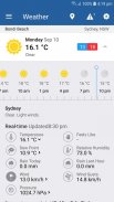
• WEATHER - Seven day BoM weather forecasts tailored to each location including min/max temperatures, and detailed weather descriptions.
• RADAR - Raw BoM radar data, refined, processed and integrated with Google maps.
• SATELLITE - National satellite view, displaying cloud cover for the entire Australian continent integrated with Google maps.
• TIDES - The most comprehensive tide times system in Australia, bringing together BoM standard port data with offsets from the Australian National Tide Tables and various state based marine agencies. Includes every beach in Australia, and many river systems and inlets.
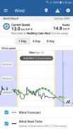
• WIND - An amalgamation of the most accurate global wind forecast models gathered from the BoM, NOAA and ECMWF, interpolated to the exact coordinates for each location and vetted against real-time wind observations to deliver the best performing information.
• UV - Hourly UV index forecasts, including alerts outlining extreme conditions when there is risk of harm from unprotected sun exposure.
• MOON PHASES - Full moon and new moon phases, illumination and rise and set times. Deeply integrated with tidal data.
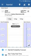
• RAINFALL - Intuitive visual indication of rainfall probability and intensity for the week ahead, using the latest ACCESS models provided by the BoM.
• SWELL - Swell height, period and direction for each beach in Australia.
• SUNRISE SUNSET - Sunrise and sunset times with first light and last light.
• REAL TIME observational data - with trends for all locations including current temperature, feels-like temperature, rain today, rain last hour, humidity, pressure, wind speed, wind direction, wind gusts and dew point.
• BOM WARNINGS - Easily accessible and specifically targeted to the locations affected.
FEATURES
• Interactive rainfall radar and satellite, using Google maps: pan and zoom like you've always wanted through the national BoM radar network, and continental satellite view to see exactly where rain is falling around you, or your favourite locations. Our mapping features provides more control, and more detail than any other Australian weather source.
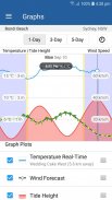
• Stunning, interactive tide, swell, and wind forecast graphs which allow you to easily understand the conditions at your favourite surf beach, secret fishing spot or upcoming hike - in real-time, and up to seven days in the future. We're particularly proud of our graphs, we pushed the boundaries to provide you with more context, and more detail for each weather type.
• A beautiful, simple and organised interface in which the weather data that is important to you is easy to find, consume and interact with. Our goal was to present accurate and relevant weather information to you, as quickly, and easily as possible.
الطقس المحلي للأستراليين
WillyWeather هو تطبيق طقس غني بالميزات يتضمن رادار BoM وأقمار صناعية ، وتنبؤات مفصلة بالرياح والأمطار والمد والجزر والأشعة فوق البنفسجية ، بالإضافة إلى مراحل القمر ، وشروق الشمس وغروبها.
بتجاوز خدمة الطقس العادية ، نقوم بمعالجة وضبط بيانات التنبؤ إلى الإحداثيات المحددة لأكثر من 17000 موقع أسترالي بما في ذلك جميع الضواحي والبلدات والشواطئ والأنهار والحدائق والبحيرات والجزر.
بيانات الطقس
• الطقس - تنبؤات الطقس لـ BoM لمدة سبعة أيام مخصصة لكل موقع بما في ذلك درجات الحرارة القصوى / القصوى ، ووصفًا مفصلاً للطقس.
• رادار - بيانات رادار BoM الخام ، المكررة والمعالجة ومتكاملة مع خرائط جوجل.
• القمر الصناعي - عرض القمر الصناعي الوطني ، وعرض الغطاء السحابي لكامل القارة الأسترالية متكاملة مع خرائط جوجل.
• TIDES - نظام أوقات المد والجزر الأكثر شمولاً في أستراليا ، حيث يجمع بيانات منفذ BoM القياسية مع إزاحات من جداول المد والجزر الوطنية الأسترالية والعديد من الوكالات البحرية القائمة في الولايات. يشمل كل شاطئ في أستراليا ، والعديد من أنظمة النهر ومداخله.
• WIND - مزيج من أكثر نماذج التنبؤ بالرياح دقة على المستوى العالمي والتي تم جمعها من BoM و NOAA و ECMWF ، وقد تم تحريفها مع الإحداثيات الدقيقة لكل موقع وتم فحصها ضد ملاحظات الرياح في الوقت الفعلي لتقديم أفضل المعلومات أداءً.
الأشعة فوق البنفسجية - تنبؤات مؤشر الأشعة فوق البنفسجية كل ساعة ، بما في ذلك التنبيهات التي تحدد الظروف القاسية عندما يكون هناك خطر الضرر الناجم عن التعرض غير المحمي للشمس.
• مراحل القمر - مراحل اكتمال القمر والقمر الجديد والإضاءة والارتفاع ومرات محددة. متكامل بعمق مع بيانات المد والجزر.
• RAINFALL - إشارة مرئية بديهية لاحتمال هطول الأمطار وكثافته للأسبوع المقبل ، وذلك باستخدام أحدث طرازات ACCESS المقدمة من BoM.
• تضخم - انتفاخ الطول والفترة والاتجاه لكل شاطئ في أستراليا.
• شروق الشمس غروب الشمس - أوقات شروق وغروب الشمس مع أول ضوء والضوء الأخير.
• بيانات رصد الوقت الحقيقي - مع الاتجاهات لجميع المواقع بما في ذلك درجة الحرارة الحالية ، ودرجة حرارة تشبه المطر ، والمطر اليوم ، والمطر في آخر ساعة ، والرطوبة ، والضغط ، وسرعة الرياح ، واتجاه الرياح ، وهبوب الرياح ونقطة الندى.
• تحذيرات BOM - يمكن الوصول إليها بسهولة وتستهدف بشكل خاص المواقع المتأثرة.
المميزات
• رادار هطول الأمطار التفاعلي والقمر الصناعي ، باستخدام خرائط Google: تحريك وتكبير / تصغير كما تريد دائمًا من خلال شبكة رادار BoM الوطنية ، وعرض القمر الصناعي القاري لمعرفة مكان سقوط المطر من حولك ، أو مواقعك المفضلة. توفر ميزات التعيين لدينا مزيدًا من التحكم ، وتفاصيل أكثر من أي مصدر طقس أسترالي آخر.
• رسومات بيانية مذهلة وتفاعلية للمد والانتفاخ والرياح تتيح لك أن تفهم بسهولة الظروف على شاطئ ركوب الأمواج المفضل لديك ، أو موقع الصيد السري أو التنزه المرتقب - في الوقت الفعلي ، وحتى سبعة أيام في المستقبل. نحن فخورون بشكل خاص بالرسوم البيانية لدينا ، لقد دفعنا الحدود لتزويدك بمزيد من السياق ، ومزيد من التفاصيل لكل نوع من أنواع الطقس.
• واجهة جميلة وبسيطة ومنظمة يسهل فيها العثور على بيانات الطقس المهمة بالنسبة لك واستهلاكها والتفاعل معها. كان هدفنا تقديم معلومات الطقس دقيقة وذات صلة لك ، في أسرع وقت ممكن.
WillyWeather - إصدار 4.0.4
(22-11-2023)WillyWeather - معلومات APK
نُسخة APK: 4.0.4الحزمة: au.com.willyweatherتطبيقات من الفئة نفسها
قد يعجبك أيضًا...


